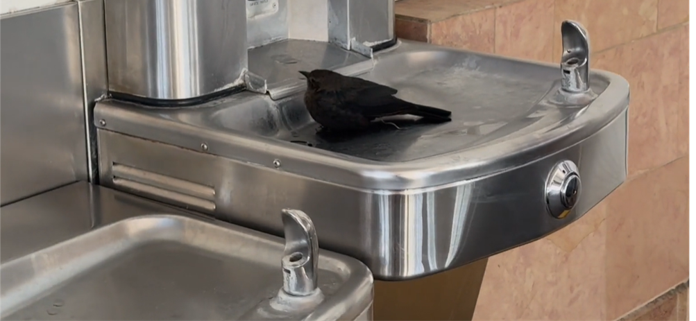
Most drinking fountains are designed with people in mind. Occasionally, however, infrastructure attracts unexpected users. While passing a public drinking fountain recently, a small bird had settled into the basin, using the remaining water much like a bird bath. The scene was simple: a bit of water, a quiet moment, and a reminder that infrastructure often interacts with the surrounding environment in ways that designers never fully anticipate. The bird appeared comfortable, resting quietly in the shallow water collected in the fountain. There was a moment of hesitation about approaching too closely. Adding more water might have been helpful, but it also might have disturbed the bird. Sometimes observation is enough. What makes moments like this interesting is that they reveal how infrastructure exists within larger systems. A drinking fountain is designed to provide water for people, but the fountain also becomes part of the surrounding environment. Birds, insects, trees, and other wildlife regularly interact with the same infrastructure that communities build for human use.
Most public infrastructure serves a specific purpose. Drinking fountains provide water. Storm drains move runoff. Sidewalks support pedestrian travel. Street trees provide shade. Yet once infrastructure is placed into a real environment, the boundaries between human systems and natural systems become less distinct.
A small amount of water in a fountain basin can become a resting place for a bird. A stormwater facility can create habitat. A tree planted for shade can support wildlife while also improving neighborhood comfort. These interactions are often minor, but they are reminders that infrastructure rarely operates in isolation.
Observations like this are easy to overlook because they do not appear in design manuals, construction drawings, or maintenance plans. Yet they are part of the everyday relationship between built environments and natural systems.
Not every observation needs to lead to a recommendation or a conclusion. Sometimes there is value in simply noticing what is happening.
In this case, a drinking fountain became something more than a drinking fountain for a few moments. A piece of public infrastructure provided a small refuge, and a quiet interaction revealed how closely connected human-built systems and the natural world can be.
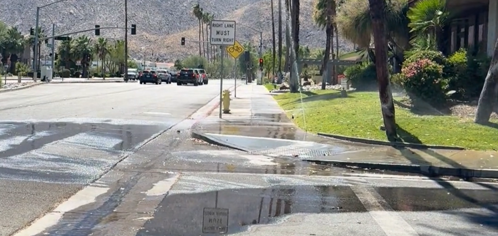
On a hot day, a sprinkler spraying across a sidewalk can feel less like a maintenance issue and more like an invitation.
Walking through the water might actually be refreshing.
At the same time, the scene highlights something that shows up frequently in water systems: water being applied where water was never intended to go.
A quick observation suggested that a sprinkler head was either damaged or missing. Instead of watering the landscape, the irrigation system was directing water onto the pavement. The water felt good, but the irrigation system was clearly communicating that something needed attention.
What makes this interesting is how often these types of issues represent what many people call “low-hanging fruit.”
Over Memorial Day weekend, a cherry-picking trip provided a useful reminder of what that phrase actually means. Most of the cherries within easy reach had already been picked. Finding additional fruit required climbing a ladder and reaching into the upper branches. The easiest opportunities were the ones closest to the ground.
Water management often works the same way.
When discussions focus on conservation, efficiency, or reducing water loss, attention sometimes moves quickly toward larger projects and more complex solutions. Yet some of the most immediate opportunities can be found through simple observation.
A missing irrigation head.
A broken nozzle.
A sprinkler spraying across pavement instead of landscaping.
These issues are often easy to identify, relatively straightforward to correct, and capable of preventing unnecessary water loss.
Not every observation requires a major conclusion. Sometimes the value comes from simply noticing a pattern and understanding what that pattern reveals about how a system is functioning.
In this case, the lesson was visible from a sidewalk on a warm afternoon.
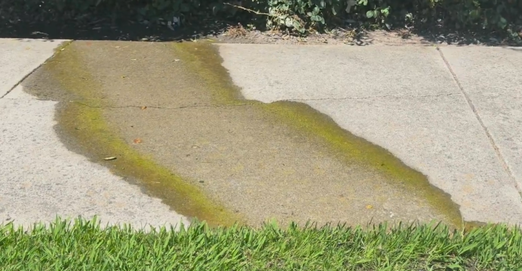
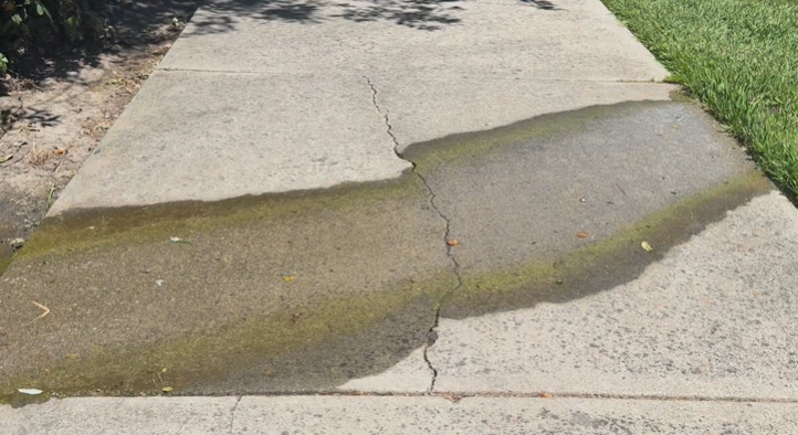
When managing public spaces, municipal parks, or neighborhood pathways, we frequently encounter small but persistent water flows across pedestrian walkways. Rather than a sudden storm surge, these localized, steady flows often originate from minor structural gaps, grading issues, or adjacent irrigation systems.
A clear example of this can be seen along a common park pathway, where water consistently seeps out of the nearby landscape, flows across the concrete, and saturates the adjacent turf.
Naming the Pattern: Persistent Base Flow and Algae Growth When a walkway experiences steady, thin sheets of water over an extended period, it alters the local surface condition. Because the concrete remains continuously damp, a distinct green band of algae develops directly within the water path. This is a common environmental response to constant moisture, creating a highly visible marker of where the water regularly moves.
In this specific area, the water emerges from the dense vegetation and soil layer bordering the uphill side of the path. It exploits a structural crack in the concrete walkway to follow the path of least resistance, cutting directly across the pedestrian path before pooling into the lawn below.
Understanding the Contributing Factors Observing these water patterns highlights several intersecting infrastructure dynamics: Subsurface and Lateral Seepage: Water frequently accumulates behind low retaining edges or vegetative borders due to overwatering, minor pipe leaks, or natural shallow groundwater movement. Once the soil saturates, the excess water pushes laterally toward lower elevations. • Grading and Structural Intersections: Concrete panels act as a barrier to shallow horizontal water movement. When a crack forms, or when the adjacent landscape grading is slightly higher than the pavement surface, the water inevitably spills across the hardscape rather than remaining contained within a subterranean or designated drainage system. • Surface Saturation: On the downhill side of the sidewalk, the continuous discharge saturates the soil beneath the grass. Over time, this constant saturation can stress local turf species, muddy the area, and cause localized soil compaction or shifting. Navigating Constraints and Practical Outcomes In municipal and civil infrastructure management, addressing every localized seepage point involves balancing clear trade-offs. Minor, non-structural flows are often monitored rather than immediately excavated, as full remediation can require extensive regrading, installing French drains, or retrofitting sub-surface drainage lines. Recognizing these patterns early allows operations and maintenance teams to track whether a flow remains stable or indicates an escalating issue, supporting sound, long-term decision-making for public assets.
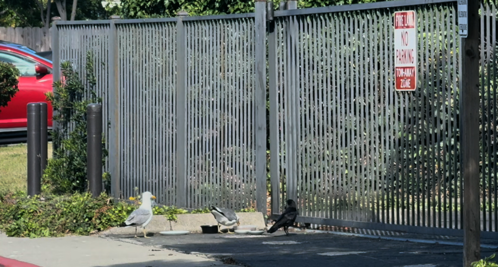
There was an unexpected wildlife gathering at a neighborhood fence recently.
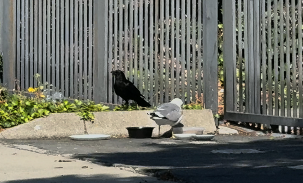
What appeared at first to be a simple bowl of food left out for stray cats quickly became something more complicated. A pair of seagulls had claimed the area, standing guard over the cat food while keeping other visitors at a distance. A crow waited nearby. Another crow joined. Somewhere inside the fenced area, a cat briefly appeared before disappearing again.
The scene became an interesting study in behavior, competition, and resource guarding.
Watching wildlife interact around a food source often reveals patterns that might otherwise go unnoticed. Different species respond to opportunities in different ways, but many behaviors appear surprisingly familiar. In this case, the seagulls were clearly attempting to control access to the food, repeatedly pushing away the crows and defending the resource.
Eventually, one crow managed to secure a piece of food. For a moment, the balance shifted. The seagulls backed off, and the crows had an opportunity to eat.
What stood out most was not simply the competition between species, but the differences within each species. There were two seagulls and two crows, and in both cases one individual appeared noticeably bolder than the other. One bird consistently approached first while the other remained more cautious.
Patterns like this appear throughout the natural world. Even among animals of the same species, responses to risk, opportunity, and competition can vary significantly.
The observation also prompted a broader question: what happens when people feed wildlife?
Many people have encountered wildlife that appears unusually comfortable around humans. On a recent hike, numerous juvenile rock squirrels approached visitors expecting food. Nearby conversations suggested some animals had been receiving snacks such as chips and other processed foods.
The situation may seem harmless or even amusing at first. Yet feeding wildlife often changes animal behavior in ways that are not immediately obvious.
Animals can begin associating people with food. Natural foraging behaviors may shift. Competition between species may increase. Animals that would not normally interact around a particular resource may suddenly find themselves competing for the same meal.
Even well-intentioned feeding efforts can produce unexpected outcomes.
A bowl of food intended for stray cats may become a feeding station for seagulls. Bird seed may attract raccoons, possums, and other visitors. Food placed for one species frequently becomes available to many others.
The result is often a complex system of interactions rather than a simple act of feeding.
Perhaps the most interesting part of the observation was how familiar some of the behaviors felt. Resource guarding is commonly discussed in domestic animals, particularly dogs. Yet similar patterns emerge across many species whenever resources become limited or concentrated in one location.
Competition, cooperation, caution, boldness, and opportunism are not unique to any one species. These behaviors appear repeatedly throughout natural systems.
Sometimes a small wildlife encounter becomes a reminder that ecosystems are connected in ways that are easy to overlook. A bowl of cat food can become a gathering place for cats, seagulls, crows, and countless behavioral interactions that unfold in real time.
Have you ever wondered how wildlife survives in urban environments?
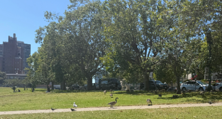
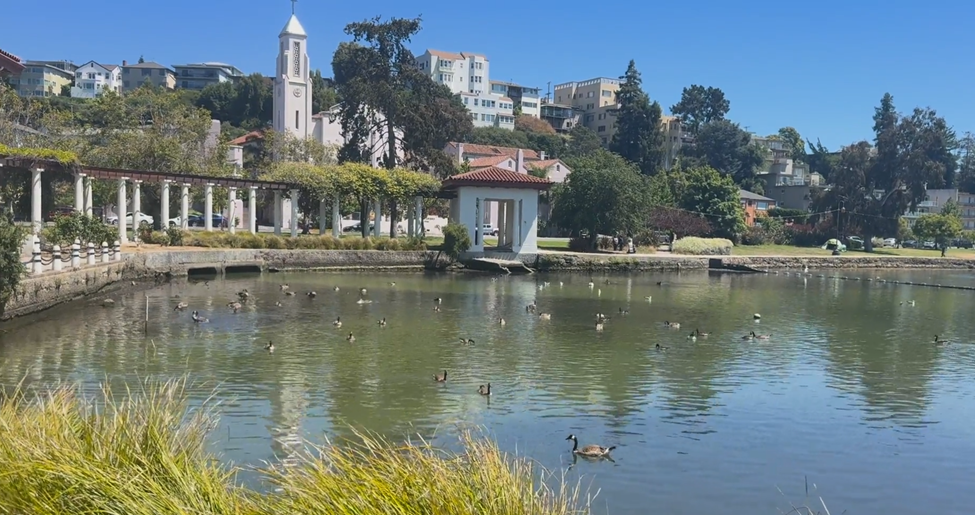
On a recent walk near a concrete flood control channel, two geese became the center of attention. Traffic noise, hard infrastructure, and the pace of the surrounding city faded into the background for a moment while the birds moved through the channel, honking at each other and pecking through vegetation growing along the water’s edge.
The setting itself was not pristine. The channel water appeared murky, with visible algae growth and accumulated sediment. Urban runoff likely carries metals, nutrients, bacteria, and other pollutants through the system. Flood control channels are typically engineered for conveyance and public safety, not habitat creation. Yet wildlife still finds ways to occupy these spaces.
That contrast is difficult to ignore.
Concrete-lined channels are often viewed only as infrastructure. The purpose is flood management, emergency access, and stormwater movement. Features like maintenance ramps, ladders, and access steps exist for operational needs, not ecological comfort. Still, vegetation establishes itself along edges and low-flow areas. Insects gather where plant growth persists. Birds adapt behavior around those patterns.
The geese repeatedly pecked through the vegetation, likely searching for insects or food sources supported by the small ecosystem developing within the channel corridor.
Urban systems frequently create unintended environmental relationships.
Some of those relationships reveal stress within the environment. Others reveal resilience.
Wildlife presence does not necessarily mean conditions are healthy. Adaptation should not be confused with ideal habitat conditions. At the same time, these observations demonstrate how living systems continue responding to available opportunities, even within highly modified environments.
That may be part of why moments like this feel grounding during urban walks.
Animals moving through infrastructure corridors can briefly shift attention away from traffic, schedules, and built surroundings. Observing wildlife in unexpected places often creates a reminder that environmental systems continue operating around and within human systems at all times.
Not perfectly. Not without constraints.
But persistently.
In many urban waterways, vegetation, insects, birds, runoff, infrastructure, erosion, and maintenance operations all interact simultaneously. These environments are rarely simple. Observing those interactions without immediately forcing conclusions can still be valuable.
Most utility infrastructure is underground, which means most people rarely think about the systems supporting everyday life.
Fire hydrants are one of the few visible reminders of those networks. While hydrants are closely associated with firefighting, hydrants also support routine maintenance, water quality management, and system testing within water distribution systems.
Walking through a neighborhood, small pieces of infrastructure begin to tell a larger story:
sanitary sewer maintenance holes
water valves
surveying monuments
drainage flow paths
utility access points
Each feature connects to systems operating beneath the street.
Even street trees are part of that conversation. Root systems compete for limited underground space alongside utilities, drainage systems, and road infrastructure.
Once infrastructure patterns become noticeable, it becomes difficult to stop seeing them. Ordinary streets begin to reveal the coordination required to support public safety, water systems, transportation, and long-term community function.
We talk a lot about innovation. We talk about growth and new ideas.
We do not talk enough about water.
And that needs to change.
Across the country, communities are facing increasing pressure on water systems. Infrastructure is aging. Climate patterns are shifting. Populations continue to grow. Yet water is still treated as something in the background instead of a leadership priority.
The reality is simple.
Water connects everything.
It influences public health, economic stability, environmental balance, and long term community resilience. When water systems fail, the impact spreads quickly and affects far more than we expect.
At Watearth, we see this every day.
Working with regional water quality boards and local environmental programs, one thing becomes clear. The most effective solutions are not reactive. They are intentional and built with the future in mind.
Leadership in this space means asking better questions.
Are we designing for today or for the next fifty years?
Are we aligning policy with real environmental conditions?
Are we involving communities as partners in the process?
It also means recognizing that technical expertise alone is not enough.
We need connection. We need to understand how water shapes everyday lives and long term outcomes.
That is why our approach brings together engineering, environmental planning, and community engagement.
Because real solutions do not exist in isolation.
They exist where disciplines, people, and purpose come together.
“The future will not be defined by what we build, but by what we choose to sustain.”
When most people look at a flood control channel, they see a simple purpose: move water from point A to point B as efficiently as possible.
But there’s more going on beneath the surface.
Flood channels are often designed and maintained for maximum flow capacity during major storm events. That typically means clearing vegetation, compacting soils, and simplifying the channel geometry. While effective for flood protection, this approach can introduce other challenges—like increased erosion, sediment buildup, and degraded water quality over time.
Interestingly, when natural elements are left in place, they can play a critical role.
Trees and vegetation—often seen as obstructions—can actually help stabilize slopes, reduce erosion, and improve overall system performance. It’s a reminder that the most effective solutions aren’t always purely engineered or purely natural—but a balance of both.
At Watearth, we regularly work at this intersection—where hydraulic performance, environmental considerations, and long-term cost all need to align. Through specialized expertise in hydrology & hydraulics, stormwater systems, and water quality modeling, we help clients evaluate these tradeoffs early and design solutions that are both resilient and cost-effective.
Why This Matters
For agencies, developers, and engineering teams, these decisions aren’t just technical—they directly impact:
Long-term maintenance costs
Regulatory compliance
System resilience
Environmental outcomes
The earlier these factors are considered, the better the results.
Learn how proper wetland delineation and early planning keep your projects on track.
Discovering wetlands after you’ve finalized site plans can trigger redesign fees, lost lots, permit delays, and months of schedule impact. The solution? Conducting a wetland delineation during early due diligence and site feasibility analysis.
What Is Wetland Delineation?
Wetland delineation identifies and maps wetland boundaries on your property. Regulated wetlands are defined by three criteria: hydrology (water presence), hydric soils (saturated soil conditions), and hydrophytic vegetation (water-adapted plants) present under normal circumstances.
Professional delineators mark these boundaries and submit them to agencies like the U.S. Army Corps of Engineers for verification through an Approved Jurisdictional Determination (AJD) or similar agency confirmation process. An AJD formally establishes whether waters or wetlands on a site are federally regulated—providing certainty before design advances too far.
Why It Matters
Finding wetlands after finalizing designs means costly redesigns, permit delays, and potentially reduced project density. Early delineation during due diligence prevents these surprises and enables informed decisions about site feasibility before major investments.
A delineation that represents a small fraction of your overall development budget can prevent six-figure redesign costs, mitigation expenses, and entitlement delays later.
When conducted early, ideally during property acquisition or feasibility analysis, wetland delineation becomes a strategic risk-management tool rather than a reactive compliance step.
Wetland delineation also strengthens underwriting confidence, supports entitlement strategy, and improves coordination between civil engineering and environmental teams.
Timeline: Initial delineation typically takes 4–12 weeks depending on site size, access, and seasonal conditions, followed by 8–16+ weeks for agency verification depending on Corps district workload and submission completeness.
Because delineations often require fieldwork during specific growing seasons, early scheduling is critical to avoid multi-month delays.
Turning Wetlands into Assets
Wetlands don’t have to be obstacles. Smart design can integrate them as open space amenities, stormwater management features, or nature preserves.
Buffer requirements often range from 25 to 100 feet depending on state and local regulations and are significantly easier to accommodate when identified early in the design process. Proactive planning preserves buildable area and protects project density.
In some cases, preserving wetlands can enhance community value, improve permitting outcomes, and support sustainability goals.
Permitting Essentials
Projects impacting jurisdictional wetlands typically require authorization under Section 404 of the Clean Water Act, along with state water quality certification (Section 401) and potentially additional state or local approvals.
Nationwide Permits cover minimal impacts with streamlined review, while Individual Permits handle larger impacts and require mitigation such as creating, restoring, or enhancing wetlands off-site, or purchasing mitigation bank credits.
Designing to add and minimize impacts before relying on mitigation can substantially reduce permitting risk, review time, and overall project cost.
Understanding which permitting pathway applies and designing to avoid or minimize impacts where possible can significantly reduce review time and mitigation costs.
Best Practices
Conduct delineation during initial site assessment
Budget for environmental studies as standard due diligence
Engage qualified professionals with local experience
Communicate with regulatory agencies early
Build buffer time into schedules for permitting delays
Coordinate wetland findings directly with site planning and grading concepts before layout is finalized.
The Bottom Line
Wetland delineation isn’t a regulatory checkbox, it’s a planning tool that protects your investment. The modest upfront cost prevents expensive surprises and streamlines the entire development process.
In land development, early environmental intelligence is often the difference between predictable delivery and costly redesign
Municipal Separate Storm Sewer System (MS4) permits are essential for protecting water quality, but they’re also one of the most frequently misunderstood regulatory requirements municipalities face. The good news? Most compliance issues are preventable. At Watearth, we’ve seen the same mistakes repeated across jurisdictions and we know how to avoid them.
Mistake #1: Treating the Permit as a One-Time Event
Many municipalities view MS4 permit acquisition as a finish line rather than a starting point. The reality is that MS4 compliance is an ongoing program requiring continuous monitoring, reporting, annual evaluation, and adaptive management.
How to avoid it: Establish annual compliance calendars with clear deadlines for monitoring, reporting, and annual reporting and program assessments. Assign dedicated staff or consultants to oversee the program year-round, not just when deadlines approach.
Generic, templated SWPPPs that don’t reflect site-specific conditions are a red flag during inspections. These documents must be living blueprints that address your actual drainage patterns, potential pollutant sources, and site operations for regulated construction and industrial activities.
How to avoid it: Conduct thorough site assessments before drafting SWPPPs. Include detailed site maps, clearly identified pollutant sources, and specific best management practices (BMPs) tailored to your operations. Update these documents whenever site conditions change or when inspections identify deficiencies.
Mistake #3: Poor Documentation and Record-Keeping
When regulators conduct inspections, they need to see proof of compliance. Missing inspection logs, incomplete monitoring data, or poorly organized records can trigger enforcement actions even when the actual stormwater management is adequate.
How to avoid it: Implement a centralized digital record-keeping system. Document all inspections, monitoring activities, maintenance work, and training sessions with dates, photos, and specific findings. Maintain these records for the duration required by your permit (often three to five years or longer).
Mistake #4: Neglecting Public Education and Outreach
MS4 permits require measurable goals for public education, yet many municipalities treat this as an afterthought. Simply posting information on a website rarely meets the intent of building community awareness about stormwater impacts.
How to avoid it: Develop targeted outreach programs for specific audiences that include residents, businesses, schools, and developers. Track participation and evaluate effectiveness through surveys or engagement metrics as required by permit-defined measurable goals. Document all activities thoroughly.
Mistake #5: Ineffective Illicit Discharge Detection and Elimination (IDDE)
Identifying and eliminating illicit connections and discharges requires systematic investigation, not reactive responses to obvious problems. Many MS4 operators lack comprehensive outfall inventories or regular dry-weather screening programs.
How to avoid it: Create a complete inventory of your outfalls with GPS coordinates and drainage area maps. Establish routine dry-weather screening schedules. Train staff to recognize signs of illicit discharges and follow documented investigation procedures and response procedures.
Mistake #6: Ignoring Construction Site Runoff Control
Construction sites are significant sources of sediment pollution, yet many MS4s have weak inspection programs or unclear enforcement authority for non-compliant sites.
How to avoid it: Develop clear ordinances that establish inspection frequencies and enforcement mechanisms consistent with state and local authority. Train inspectors on erosion control BMPs and documentation requirements. Maintain communication with project owners and contractors before problems escalate.
Mistake #7: Underestimating BMP Maintenance Needs
Installing structural BMPs like detention basins, bioswales, or permeable pavement satisfies design requirements, but these systems fail without proper maintenance. Clogged facilities can make problems worse by causing flooding or bypassing treatment.
How to avoid it: Create maintenance schedules for every BMP with specific inspection criteria and maintenance triggers. Budget adequately for long-term upkeep. Consider maintenance requirements during the design phase—simpler systems often perform better over time and are easier to document for compliance purposes.
Mistake #8: Failing to Track Regulatory Changes
MS4 permit requirements evolve. New pollutants of concern, updated monitoring protocols, and revised performance standards or reporting expectations can appear in renewed permits, catching unprepared municipalities off guard.
How to avoid it: Subscribe to regulatory updates from your state environmental agency and EPA Region. Join professional associations and attend training sessions. Begin preparing for permit renewal at least two years in advance.
The Bottom Line
MS4 compliance doesn’t have to be overwhelming. The key is treating it as a systematic program with clear procedures, adequate resources, and committed leadership. Most violations result from organizational gaps, not technical impossibilities.
At Watearth, we help municipalities build sustainable MS4 programs that protect water quality while managing compliance efficiently. Whether you need assistance with permit applications, SWPPP development, BMP design, or compliance audits, we’re here to help you avoid these common pitfalls.