Have you ever wondered how wildlife survives in urban environments?
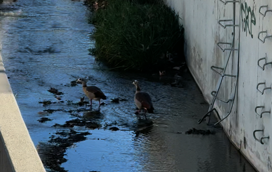
On a recent walk near a concrete flood control channel, two geese became the center of attention. Traffic noise, hard infrastructure, and the pace of the surrounding city faded into the background for a moment while the birds moved through the channel, honking at each other and pecking through vegetation growing along the water’s edge.
The setting itself was not pristine. The channel water appeared murky, with visible algae growth and accumulated sediment. Urban runoff likely carries metals, nutrients, bacteria, and other pollutants through the system. Flood control channels are typically engineered for conveyance and public safety, not habitat creation. Yet wildlife still finds ways to occupy these spaces.
That contrast is difficult to ignore.
Concrete-lined channels are often viewed only as infrastructure. The purpose is flood management, emergency access, and stormwater movement. Features like maintenance ramps, ladders, and access steps exist for operational needs, not ecological comfort. Still, vegetation establishes itself along edges and low-flow areas. Insects gather where plant growth persists. Birds adapt behavior around those patterns.
The geese repeatedly pecked through the vegetation, likely searching for insects or food sources supported by the small ecosystem developing within the channel corridor.
Urban systems frequently create unintended environmental relationships.
Some of those relationships reveal stress within the environment. Others reveal resilience.
Wildlife presence does not necessarily mean conditions are healthy. Adaptation should not be confused with ideal habitat conditions. At the same time, these observations demonstrate how living systems continue responding to available opportunities, even within highly modified environments.
That may be part of why moments like this feel grounding during urban walks.
Animals moving through infrastructure corridors can briefly shift attention away from traffic, schedules, and built surroundings. Observing wildlife in unexpected places often creates a reminder that environmental systems continue operating around and within human systems at all times.
Not perfectly. Not without constraints.
But persistently.
In many urban waterways, vegetation, insects, birds, runoff, infrastructure, erosion, and maintenance operations all interact simultaneously. These environments are rarely simple. Observing those interactions without immediately forcing conclusions can still be valuable.
Most utility infrastructure is underground, which means most people rarely think about the systems supporting everyday life.
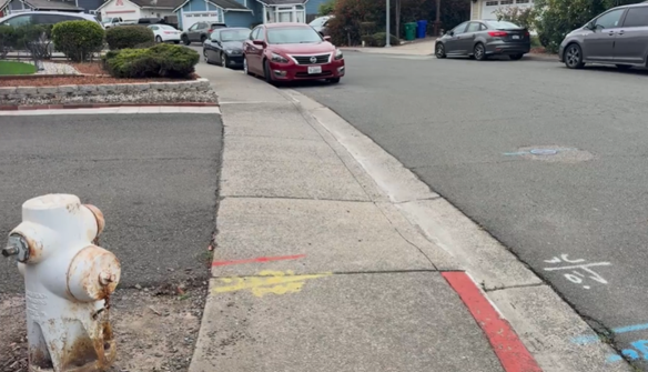
Fire hydrants are one of the few visible reminders of those networks. While hydrants are closely associated with firefighting, hydrants also support routine maintenance, water quality management, and system testing within water distribution systems.
Walking through a neighborhood, small pieces of infrastructure begin to tell a larger story:
sanitary sewer maintenance holes
water valves
surveying monuments
drainage flow paths
utility access points
Each feature connects to systems operating beneath the street.
Even street trees are part of that conversation. Root systems compete for limited underground space alongside utilities, drainage systems, and road infrastructure.
Once infrastructure patterns become noticeable, it becomes difficult to stop seeing them. Ordinary streets begin to reveal the coordination required to support public safety, water systems, transportation, and long-term community function.
We talk a lot about innovation. We talk about growth and new ideas.
We do not talk enough about water.
And that needs to change.
Across the country, communities are facing increasing pressure on water systems. Infrastructure is aging. Climate patterns are shifting. Populations continue to grow. Yet water is still treated as something in the background instead of a leadership priority.
The reality is simple.
Water connects everything.
It influences public health, economic stability, environmental balance, and long term community resilience. When water systems fail, the impact spreads quickly and affects far more than we expect.
At Watearth, we see this every day.
Working with regional water quality boards and local environmental programs, one thing becomes clear. The most effective solutions are not reactive. They are intentional and built with the future in mind.
Leadership in this space means asking better questions.
Are we designing for today or for the next fifty years?
Are we aligning policy with real environmental conditions?
Are we involving communities as partners in the process?
It also means recognizing that technical expertise alone is not enough.
We need connection. We need to understand how water shapes everyday lives and long term outcomes.
That is why our approach brings together engineering, environmental planning, and community engagement.
Because real solutions do not exist in isolation.
They exist where disciplines, people, and purpose come together.
“The future will not be defined by what we build, but by what we choose to sustain.”
When most people look at a flood control channel, they see a simple purpose: move water from point A to point B as efficiently as possible.
But there’s more going on beneath the surface.
Flood channels are often designed and maintained for maximum flow capacity during major storm events. That typically means clearing vegetation, compacting soils, and simplifying the channel geometry. While effective for flood protection, this approach can introduce other challenges—like increased erosion, sediment buildup, and degraded water quality over time.
Interestingly, when natural elements are left in place, they can play a critical role.
Trees and vegetation—often seen as obstructions—can actually help stabilize slopes, reduce erosion, and improve overall system performance. It’s a reminder that the most effective solutions aren’t always purely engineered or purely natural—but a balance of both.
At Watearth, we regularly work at this intersection—where hydraulic performance, environmental considerations, and long-term cost all need to align. Through specialized expertise in hydrology & hydraulics, stormwater systems, and water quality modeling, we help clients evaluate these tradeoffs early and design solutions that are both resilient and cost-effective.
Why This Matters
For agencies, developers, and engineering teams, these decisions aren’t just technical—they directly impact:
Long-term maintenance costs
Regulatory compliance
System resilience
Environmental outcomes
The earlier these factors are considered, the better the results.
Learn how proper wetland delineation and early planning keep your projects on track.
Discovering wetlands after you’ve finalized site plans can trigger redesign fees, lost lots, permit delays, and months of schedule impact. The solution? Conducting a wetland delineation during early due diligence and site feasibility analysis.
What Is Wetland Delineation?
Wetland delineation identifies and maps wetland boundaries on your property. Regulated wetlands are defined by three criteria: hydrology (water presence), hydric soils (saturated soil conditions), and hydrophytic vegetation (water-adapted plants) present under normal circumstances.
Professional delineators mark these boundaries and submit them to agencies like the U.S. Army Corps of Engineers for verification through an Approved Jurisdictional Determination (AJD) or similar agency confirmation process. An AJD formally establishes whether waters or wetlands on a site are federally regulated—providing certainty before design advances too far.
Why It Matters
Finding wetlands after finalizing designs means costly redesigns, permit delays, and potentially reduced project density. Early delineation during due diligence prevents these surprises and enables informed decisions about site feasibility before major investments.
A delineation that represents a small fraction of your overall development budget can prevent six-figure redesign costs, mitigation expenses, and entitlement delays later.
When conducted early, ideally during property acquisition or feasibility analysis, wetland delineation becomes a strategic risk-management tool rather than a reactive compliance step.
Wetland delineation also strengthens underwriting confidence, supports entitlement strategy, and improves coordination between civil engineering and environmental teams.
Timeline: Initial delineation typically takes 4–12 weeks depending on site size, access, and seasonal conditions, followed by 8–16+ weeks for agency verification depending on Corps district workload and submission completeness.
Because delineations often require fieldwork during specific growing seasons, early scheduling is critical to avoid multi-month delays.
Turning Wetlands into Assets
Wetlands don’t have to be obstacles. Smart design can integrate them as open space amenities, stormwater management features, or nature preserves.
Buffer requirements often range from 25 to 100 feet depending on state and local regulations and are significantly easier to accommodate when identified early in the design process. Proactive planning preserves buildable area and protects project density.
In some cases, preserving wetlands can enhance community value, improve permitting outcomes, and support sustainability goals.
Permitting Essentials
Projects impacting jurisdictional wetlands typically require authorization under Section 404 of the Clean Water Act, along with state water quality certification (Section 401) and potentially additional state or local approvals.
Nationwide Permits cover minimal impacts with streamlined review, while Individual Permits handle larger impacts and require mitigation such as creating, restoring, or enhancing wetlands off-site, or purchasing mitigation bank credits.
Designing to add and minimize impacts before relying on mitigation can substantially reduce permitting risk, review time, and overall project cost.
Understanding which permitting pathway applies and designing to avoid or minimize impacts where possible can significantly reduce review time and mitigation costs.
Best Practices
Conduct delineation during initial site assessment
Budget for environmental studies as standard due diligence
Engage qualified professionals with local experience
Communicate with regulatory agencies early
Build buffer time into schedules for permitting delays
Coordinate wetland findings directly with site planning and grading concepts before layout is finalized.
The Bottom Line
Wetland delineation isn’t a regulatory checkbox, it’s a planning tool that protects your investment. The modest upfront cost prevents expensive surprises and streamlines the entire development process.
In land development, early environmental intelligence is often the difference between predictable delivery and costly redesign
Municipal Separate Storm Sewer System (MS4) permits are essential for protecting water quality, but they’re also one of the most frequently misunderstood regulatory requirements municipalities face. The good news? Most compliance issues are preventable. At Watearth, we’ve seen the same mistakes repeated across jurisdictions and we know how to avoid them.
Mistake #1: Treating the Permit as a One-Time Event
Many municipalities view MS4 permit acquisition as a finish line rather than a starting point. The reality is that MS4 compliance is an ongoing program requiring continuous monitoring, reporting, annual evaluation, and adaptive management.
How to avoid it: Establish annual compliance calendars with clear deadlines for monitoring, reporting, and annual reporting and program assessments. Assign dedicated staff or consultants to oversee the program year-round, not just when deadlines approach.
Generic, templated SWPPPs that don’t reflect site-specific conditions are a red flag during inspections. These documents must be living blueprints that address your actual drainage patterns, potential pollutant sources, and site operations for regulated construction and industrial activities.
How to avoid it: Conduct thorough site assessments before drafting SWPPPs. Include detailed site maps, clearly identified pollutant sources, and specific best management practices (BMPs) tailored to your operations. Update these documents whenever site conditions change or when inspections identify deficiencies.
Mistake #3: Poor Documentation and Record-Keeping
When regulators conduct inspections, they need to see proof of compliance. Missing inspection logs, incomplete monitoring data, or poorly organized records can trigger enforcement actions even when the actual stormwater management is adequate.
How to avoid it: Implement a centralized digital record-keeping system. Document all inspections, monitoring activities, maintenance work, and training sessions with dates, photos, and specific findings. Maintain these records for the duration required by your permit (often three to five years or longer).
Mistake #4: Neglecting Public Education and Outreach
MS4 permits require measurable goals for public education, yet many municipalities treat this as an afterthought. Simply posting information on a website rarely meets the intent of building community awareness about stormwater impacts.
How to avoid it: Develop targeted outreach programs for specific audiences that include residents, businesses, schools, and developers. Track participation and evaluate effectiveness through surveys or engagement metrics as required by permit-defined measurable goals. Document all activities thoroughly.
Mistake #5: Ineffective Illicit Discharge Detection and Elimination (IDDE)
Identifying and eliminating illicit connections and discharges requires systematic investigation, not reactive responses to obvious problems. Many MS4 operators lack comprehensive outfall inventories or regular dry-weather screening programs.
How to avoid it: Create a complete inventory of your outfalls with GPS coordinates and drainage area maps. Establish routine dry-weather screening schedules. Train staff to recognize signs of illicit discharges and follow documented investigation procedures and response procedures.
Mistake #6: Ignoring Construction Site Runoff Control
Construction sites are significant sources of sediment pollution, yet many MS4s have weak inspection programs or unclear enforcement authority for non-compliant sites.
How to avoid it: Develop clear ordinances that establish inspection frequencies and enforcement mechanisms consistent with state and local authority. Train inspectors on erosion control BMPs and documentation requirements. Maintain communication with project owners and contractors before problems escalate.
Mistake #7: Underestimating BMP Maintenance Needs
Installing structural BMPs like detention basins, bioswales, or permeable pavement satisfies design requirements, but these systems fail without proper maintenance. Clogged facilities can make problems worse by causing flooding or bypassing treatment.
How to avoid it: Create maintenance schedules for every BMP with specific inspection criteria and maintenance triggers. Budget adequately for long-term upkeep. Consider maintenance requirements during the design phase—simpler systems often perform better over time and are easier to document for compliance purposes.
Mistake #8: Failing to Track Regulatory Changes
MS4 permit requirements evolve. New pollutants of concern, updated monitoring protocols, and revised performance standards or reporting expectations can appear in renewed permits, catching unprepared municipalities off guard.
How to avoid it: Subscribe to regulatory updates from your state environmental agency and EPA Region. Join professional associations and attend training sessions. Begin preparing for permit renewal at least two years in advance.
The Bottom Line
MS4 compliance doesn’t have to be overwhelming. The key is treating it as a systematic program with clear procedures, adequate resources, and committed leadership. Most violations result from organizational gaps, not technical impossibilities.
At Watearth, we help municipalities build sustainable MS4 programs that protect water quality while managing compliance efficiently. Whether you need assistance with permit applications, SWPPP development, BMP design, or compliance audits, we’re here to help you avoid these common pitfalls.
Watearth is leading the Mills Tower Drainage Feasibility Study for the City of Rancho Cordova The study addresses persistent flooding across a 152-acre drainage area with constrained pump station capacity.
Over the course of the project, Watearth has reviewed the City’s Master Plan, FEMA documentation, topographic and soils data, and hydrologic and hydraulic models. Initial site visits and a kickoff meeting helped validate desktop findings and identify opportunities for flood mitigation, including detention basins at White Rock Elementary School and Community Park, as well as distributed low impact development (LID) features.
Stormwater drain at western boundary of White Rock Elementary School playfield – Looking Northwest toward parking lotMills Tower Pump Station – Facing Northbound
Simulations for 10-year and 100-year storm events informed the performance evaluation of alternatives. The team has produced 10% concept layouts that integrate flood control, water quality, and recreational benefits, along with preliminary cost estimates and a comparative cost-benefit analysis. Deliverables include a detailed technical memorandum and ongoing virtual coordination with City staff.
At Watearth, one of the most critical decisions we make is selecting the right modeling approach for each project. Choosing the wrong model can lead to cost overruns, false confidence in designs, or missed flood risks that put communities in danger. The key is matching model complexity to the problem at hand.
When to Use 1D Modeling. One-dimensional models analyze flow along a single axis and are ideal for well-defined channels, culvert and bridge hydraulics, stream capacity analysis, and preliminary floodplain assessments. They’re efficient and can evaluate long reaches of river systems quickly, making them perfect for projects where cross-sectional data is sufficient. However, 1D models have limitations—they cannot capture lateral flow spreading or complex flow patterns that occur in wide floodplains or areas with multiple flow paths.
When 2D Modeling Makes Sense. When 1D assumptions break down, two-dimensional modeling becomes essential. We use 2D models for complex floodplain analysis with multiple flow paths, coastal and estuarine systems, dam breach scenarios, and urban flooding where streets become channels. While 1D shows you water elevation, 2D reveals where water actually goes and how fast it moves. This additional detail requires more extensive terrain data and greater computational resources, but for complex flow scenarios, the investment is necessary to capture the true hydraulic behavior.
The Role of Unsteady Flow Analysis. Unsteady flow modeling adds the time dimension to either 1D or 2D models, tracking how conditions evolve rather than assuming equilibrium. This approach is critical for flood routing and reservoir operations, storm surge prediction, dam failure studies, and any scenario where timing drives risk. We recently modeled Harris Reservoir where steady-state analysis showed adequate capacity, but unsteady modeling revealed conditions that could overwhelm outlet structures—an insight that drove critical design changes.
Hybrid Modeling in Action: Rubio Wash. Watearth supported the Rubio Wash subwatershed drainage study by delivering advanced hydrology and 1D/2D hydraulic modeling for one of Los Angeles’s most critical flood control corridors. The project combined detailed GIS-based storm drain inventories with MODRAT hydrology and XPSWMM modeling to identify system deficiencies under 10-, 25-, and 50-year storm events and guide future flood mitigation efforts.
Our Approach. We start by asking: What decisions will this analysis inform? What accuracy do stakeholders need? Sometimes the answer is hybrid—1D for an entire watershed with 2D focus on critical areas. There’s no universal “best” modeling approach. Our role is matching sophistication to project needs, delivering the insights you need for confident decisions without unnecessary complexity or cost.
Have a water resources challenge? Contact our team to learn how we solve complex water problems with the right engineering approach.
Efficient water distribution is critical for ensuring reliable water supply and regulatory compliance. Advanced hydraulic and water quality modeling helps utilities and municipalities manage system performance, identify deficiencies, and comply with regulations. Watearth specializes in water distribution modeling across California, Arizona, Texas, and nationwide, providing tailored solutions for varying infrastructure needs.
Hydraulic Modeling: Ensuring System Efficiency
Water distribution networks must be designed and maintained to handle various demand scenarios. Our hydraulic modeling services analyze key performance metrics such as:
Pressure Management – Assessing pressure fluctuations during average day, peak hour, and fire flow conditions in major metro areas such as Los Angeles, and Houston.
Flow Velocities & Rate Adjustments – Ensuring optimal movement of water throughout the system to minimize inefficiencies.
System Calibration – Fine-tuning hydraulic models to match real-world conditions, using historical and real-time data for accuracy.
Water Quality Modeling: Compliance & Public Health Protection
Water quality is a top priority for utilities, particularly in urban regions. Our modeling capabilities include:
Disinfection Byproducts (DBPs) Analysis – Monitoring and predicting DBP formation to ensure compliance with EPA standards.
Water Age Tracking – Evaluating how long water remains in the system, which impacts residual chlorine levels and overall water quality.
Source Water Management – Optimizing blending strategies for surface and groundwater sources to balance quality and cost.
Regional & Nationwide Expertise
Watearth provides comprehensive modeling services across California, Arizona, and Texas. Our nationwide reach allows us to adapt to diverse regulatory frameworks, environmental conditions, climates, and urban infrastructure challenges.
Why Choose Watearth?
Over 17 Years of Expertise in hydraulic and water quality modeling.
Regulatory Compliance support for EPA, state, and local standards.
Advanced Modeling Tools using GIS, EPANET, and other industry-leading software.
Custom Solutions for municipalities, water districts, and private clients.
Small business accessibility
Get Started with Watearth
If you need expert water distribution system modeling in California, Texas, or anywhere in the U.S., contact us today. Our team is ready to help you optimize your system for efficiency, resilience, and compliance.
📞 Call us at 877.302.2084 🌐 Visit us at watearth.com
Stormwater runoff from roads and parking lots is more than just water — it’s a vehicle for hydrocarbons and other pollutants from gas-powered cars that end up in our rivers, lakes, and oceans.
That’s where bioretention comes in.
As a leading stormwater best management practice (BMP), bioretention systems naturally filter pollutants through engineered soils and vegetation. These systems not only help manage runoff but also improve water quality, recharge groundwater, and enhance green spaces.
At Watearth, we specialize in sustainable stormwater design solutions that protect the environment while meeting the technical and regulatory needs of every project. From hydrology modeling to stormwater treatment and green infrastructure, our niche expertise helps clients make a real impact.
🌱 Want your next project to do more for the planet?