HCID 17, Harris Precinct 4, HCFCD, and HCTRA Willow Creek Industrial Park M124 Watershed Study/Master Drainage Plan
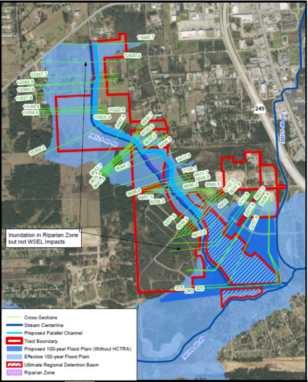
Performed watershed-wide drainage analysis for multi-phases of development of a 1,700-acre commercial and industrial site and surrounding watershed, including development for Harris County Flood Control District and Harris County Toll Road Authority (HCTRA), to evaluate downstream impacts. Performed Low Impact Development planning, design, HEC-HMS modeling, HEC-RAS Modeling, and SWMM modeling and analysis (vegetated swales, bioretention/biofiltration, extended detention). Project included stream restoration, channel improvements, parallel channels, regional detention, water quality, LID design drawings, plant palettes for LID features, hydrology and hydraulic modeling and design. Managed GIS production, including watershed delineation, hydrologic parameter development, hydraulic parameter development, cutting cross-sections, HEC-HMS and HEC-RAS model pre-processing, flood plain and flood way mapping, inundation mapping of various design storm events, environmental mapping, ordinary highwater mark mapping, and mapping of easements and recreational areas. Included stream mitigation, permitting assistance, and high water mark.
Performed watershed-wide drainage analysis for multi-phases of development of a 1,700-acre commercial and industrial site and surrounding watershed, including development for Harris County Flood Control District and Harris County Toll Road Authority (HCTRA), to evaluate downstream impacts. Performed Low Impact Development planning, design, HEC-HMS modeling, HEC-RAS Modeling, and SWMM modeling and analysis (vegetated swales, bioretention/biofiltration, extended detention). Project included stream restoration, channel improvements, parallel channels, regional detention, water quality, LID design drawings, plant palettes for LID features, hydrology and hydraulic modeling and design. Managed GIS production, including watershed delineation, hydrologic parameter development, hydraulic parameter development, cutting cross-sections, HEC-HMS and HEC-RAS model pre-processing, flood plain and flood way mapping, inundation mapping of various design storm events, environmental mapping, ordinary highwater mark mapping, and mapping of easements and recreational areas. Included stream mitigation, permitting assistance, and high water mark.

