WatearthProjectsSan Francisco Estuary Institute (SFEI) Bay Area Regional Green Infrastructure Tool and Green Plan-It Master Plan (Prop 84 Grant)
San Francisco Estuary Institute (SFEI) Bay Area Regional Green Infrastructure Tool and Green Plan-It Master Plan (Prop 84 Grant)
Client: San Francisco Estuary Institute (SFEI)
Location: Bay Area, CA
Project Size: 2,944,000ac.
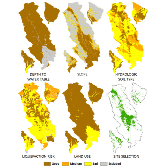
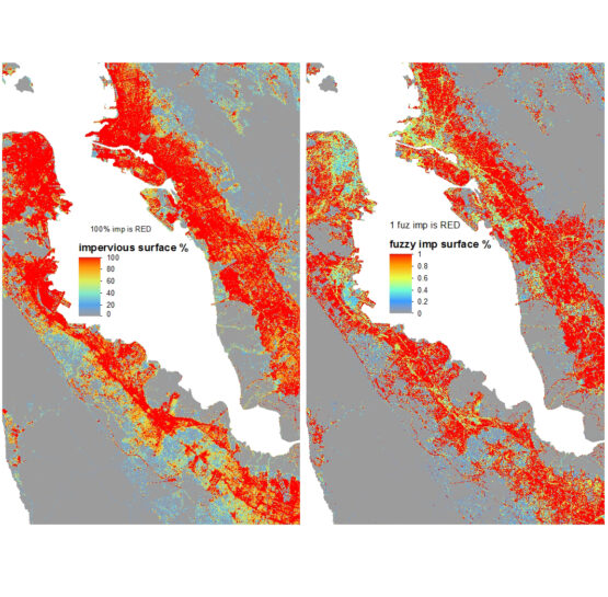
Provided technical input, support, and peer review for GIS-based Green Infrastructure sizing/site selection tool for the Bay area. Provided guidance and recommendations on depths to groundwater, depths to bedrock, slopes, liquefaction risk, soil type, land use, impervious cover, and buffers from contaminated sites related to applicability for Bioretention, Vegetated Swales, Porous Pavement, Stormwater Wetlands, and Wet Ponds. Assigned weighting and fuzzy logic weights for decision support system (DSS) analysis to determine suitable sites for these BMPs. The initial GI features included bioretention (unlined), vegetated swales, storm water wetlands, permeable pavement, and wet detention ponds. As a second phase of the project, the GI feasibility matrix was updated with bioretention (lined), infiltration trenches, flow-through planter boxes, and tree boxes. Performed modeling of Sonoma Creek watershed in SWMM and HEC-HMS to estimate the benefits of wide-scale Green Infrastructure implementation for various levels of impervious cover. Developed Green Infrastructure (GI) Master Plan. Performed watershed-wide GI and water quality modeling. Performed cost optimization. Included NPDES and MS4 Program compliance and water conservation. Watearth served as a technical expert for LID, hydrology and water quality modeling for watersheds in San Jose and Oakland. Provided GIS services including database development, weighting and ranking, decision support system development, mapping, development of hydrologic parameters, HEC-HMS and SWMM model pre-processing, and mapping.